 I am a research professor in the UMass Amherst Geoscience department. I am interested in how human perturbations to flows of water and sediment affect physical and ecological systems. This broad interest is divided into a few main study areas:
- How do coastal conditions drive the evolution of tidal wetland systems? What changes can we expect in a warming climate with increases in extreme weather and the rate of sea level rise.
- What is the resilience of tidal wetland and coastal sedimentary systems and how can restoration and intervention approaches improve resilience?
- How do changes in catchment processes – both local land use and climate-related – affect the delivery of sediment from upland areas to lakes, reservoirs, and the coast.
Statement on Inclusion in the Geosciences
One of the thrills of working in research is the impact that our results and findings can have to make people’s lives better and improve the world. That happens best when a diversity of viewpoints are represented.
The discipline of geology is one of the oldest in western science, with a rich history and many exciting discoveries that have changed worldviews around the globe. The same history is rife with unfortunate wrongs that we must reckon with: colonialism, extraction and environmental harm, environmental injustices, sexism / misogyny, and racism. I strive to help with the dismantling of these harmful forces that are still with us as a discipline. Here are some efforts that I support:
- Support departmental participation in AGU Bridge
- Actively amplify the voices and research findings of scientists from minoritized backgrounds
- Serve on the departmental DEI committee since 2018
- Introduce students to fieldwork in a way that is inclusive and intentional about reducing harm and risks to folks from minoritized backgrounds
- Volunteer work with Fort River Watershed Association to provide more outdoor opportunities to environmental justice communities.
- Actively recruit students from underrepresented backgrounds to work in my lab and on research projects
- *please reach out if you have more ideas
Here are some current projects that I am working on:
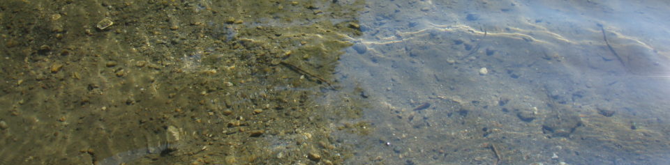
Salt Marshes and Abrupt Sea Level Rise – In 1898, a coastal storm eroded a new opening in a beach, behind which a salt marsh extends inland along two tidal channels. The new inletshortened the distance from the open ocean to parts of the salt marsh, causing high tides that flood the salt marsh to increase more than 30 cm. We considered this “natural experiment” in increased tidal flooding to understand how other marshes might survive rapid sea level rise (SLR). Sediment core samples from the marsh showed that higher tides after the inlet switch resulted in lots of mineral sediment deposited on the marsh platform. This shows that mineral sediment is very important to salt marsh survival when sea level is rising fast.
Download the paper here: Yellen_etal_2022_Salt Marsh Response to Inlet Switch?Induced Increases in Tidal Inundation

Dams and Sediment on the Hudson– along with collaborators at Woods Hole Oceanographic Inst. and the Hudson River National Estuarine Research Reserve, we are helping river managers and dam owners better understand the sediment impacts of dam removal on the Hudson River estuary. With input from an advisory committee made up of stakeholders with a variety of perspectives, this project produced a tool for dam owners to make an initial assessment of sediment inventory in their dam as they weigh dam removal. Three papers are forthcoming: (1) aggregate impacts of dams trapping sediments; (2) response of Hudson tidal marshes to channel modifications; (3) turbidity hysteresis following 2011 Hurricane Irene. Data from this project can be found at UMass Scholarworks data repository.
Manuscripts from this research:
Coastal Sediment and Armoring – Along exposed coasts, humans have built seawalls and other structures to protect homes and infrastructure from erosion. We believe that reduced erosion as a result of this coastal armoring has actually made it harder for salt marshes to survive in proximity to urbanizing, armored shorelines, as they no longer receive sediment from eroding coasts.
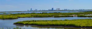
An salt marsh growing close to an urbanizing coast.
Data from this project will be released here.
High Resolution Mapping of Blue Carbon
Roughly a third of global CO2 emissions have been absorbed by the ocean, with much of that carbon stored as organic material in tidal wetlands. Tidal wetlands are uniquely able to store carbon, making them essential tools to mitigate global CO2 emissions. First, temperate tidal wetlands display exceptional levels of net primary productivity, rivaling mature tropical rain forests. Second, they trap allochthonous carbon as they accrete sediment. Third, rather than plateauing at a stable total carbon content as would be expected in most terrestrial ecosystems, tidal marshes continually store additional carbon as they accrete in step with sea level rise. As a result of this continual accumulation, salt marshes annually store roughly twenty times more carbon per unit area than forests. In light of the growing value of carbon, with stored carbon stocks valued in excess of $100 per ton and projected to increase to more than $200 per ton by 2050 (2007 dollars), an estimate of future carbon storage will add to the urgency to restore tidal marshes. Given the likely development of carbon markets in the near future, accounting for the value of carbon stored in tidal wetlands aligns closely with USDA’s mission to expand economic opportunities in rural America.
With collaboration with NRCS scientists, UMass graduate students Wenxiu Teng and Bonnie Turek, as well as UMass collaborators Qian Yu, Jon Woodruff, Tim Cook, and Justin Richardson. This work is mostly complete now, with blue carbon and marsh soil properties provided across the Northeast US, from New York to Maine.
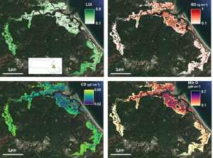
Maps of tidal marsh soil properties to quantify blue carbon and resilience metrics for salt marshes
Historical Perspectives on Sediment Mitigation– Along with Scott Steinschneider and Keith Ahn (both of Cornell), I am studying the sediment archives in one of New York City’s largest water supply reservoirs. NYC is one of five municipalities in the country that holds a filtration avoidance permit from the EPA, allowing them to distribute unfiltered (but treated) water to its customers. This permit was acquired and is maintained through NYC’s exceptional watershed management program, which ensures high quality source water. Sediment in the reservoir’s bottom informs us as to how well various measures over the last century have fared in reducing sediment loading of the reservoir. This is the first paper that has come out of this research.
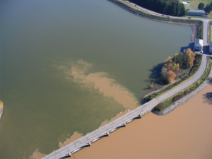
Ashokan Reservoir – Sediment spills from the inlet proximal west basin into east basin. 1999 Hurricane Floyd.
Sustainability and Hydroelectricity– Hydroelectric power is often touted as a clean solution to energy challenges. However, hydroelectric generation comes with myriad well-documented adverse effects. Along with Eve Vogel and others at UMass, I am studying how changes to energy markets have affected the operation of hydroelectric facilities and in turn affected downstream river reaches.
Extreme Event Sedimentology – Destructive floods from rainfall and coastal storm surge can leave sedimentary layers in lagoons, reservoirs, and lakes that are distinct from background sedimentation. I use sediment cores to understand changes in past frequency and magnitude of these extreme events. By coupling modern observations with sedimentology, we can extend inferences from often short-term gauge records to longer time-spans. Ongoing research is examining the erosivity of Hurricane Maria in the uplands of Puerto Rico.
Hydropeaking and Riparian Forests– Hydropeaking – hydroelectic dam releases corresponding to periods of energy demand and price increases – has been shown to cause water to be lost from downstream river reaches. During a release, river water downstream of the dam is pushed into the bank, removing much of it from the river and denying it from downstream users such as farmers, municipalities, and ecosystems. I am studying how this water is taken up by trees and to what extent hydropeaking robs rivers of their water.
I am also interested in the development of floodplains over time and combining records of sedimentation and forest development in floodplains. This paper, with collaborators Christian Marks and Keith Nislow, shows how geomorphic conditions in floodplains influence tree bioproductivity.

Teaching I have a masters of education in secondary science and taught for three years as a Teach for America corps member at a public school in rural Hawaii. As an instructor at UMass, I was awarded the university’s most prestigious teaching award (two awarded per year). Here are some courses that I have taught:
- Hydrogeology
- Sedimentology
- Introductory Geology
byellen < a t > umass.edu