In an era of collapsing biological and cultural diversity, Vanuatu is one of our planet’s last great places. Lying west of Fiji and on the eastern edge of The Coral Sea, this remote archipelago of 83 islands and open ocean is home to a vast treasure trove of biological riches — from coral reefs to mangrove and rain forests — and an enduring interdependence between its people and their natural environment. The archipelago’s conservation champions and best hope are the Vanua-tai (Land & Sea), a remarkable Indigenous group of 400 environmental stewards crafting local solutions to global crises. The Vanua-tai have asked Island Reach, a unique, US-based conservation project operating in Vanuatu, to provide a vessel for the Vanua-tai. Working on board Research Vessel Llyr, Island Reach is partnering with them to fill transportation gaps and provide a mobile work platform, skilled and professional services and training, and greater opportunities for collaboration and exchange among the Vanua-tai.
The intimate relationship between Ni-Vanuatu (the people of Vanuatu) and their lands and seas finds expression in the densest language diversity on the planet, with over 120 languages in active use! In most of Vanuatu’s 1000 villages, there is no electricity, there are no roads, and small boat motors are rare. Work — from fishing to forest farming — is done with skilled hands. Vanuatu is in a race to protect this rich heritage from the rapidly intensifying effects of climate change, extractive industries such as logging, mining, and foreign fishing fleets, and population shifts.
Now, more than ever, there is urgent need for these volunteers to work with their village Chiefs, farmers, fishers, and families to build sustainable solutions. The Vanua-tai are eager to engage; they know what they need: but for many of them, especially those in remote locations, access to resources, training, and opportunities for exchange is insufficient to meet the sheer number of mounting challenges. As a result, many Vanua-tai are struggling with projects that are stalled or under-developed.
What is Island Reach?
Island Reach is a volunteer, ocean-going project in Vanuatu, conceived and built by a New England farming family headed by a couple of social scientists trained in Human Ecology and Cultural Anthropology.
As forest farmers, we’ve spent many years developing strategies to support small-scale harvesters and we’ve spoken widely about food, economies, culture, and the environment. In 2010, with dire reports about the state of the planet and our oceans on the rise, we were compelled to greater action.
Our plan was to target the resource shortages that impede conservation efforts in island and coastal settings. This was a personal and professional decision that involved mortgaging the farm, purchasing and refitting Research Vessel Llyr, and training as offshore “bluewater” mariners. Harvesting a perennial crop meant that our work schedule could be adjusted so that we could be on the farm for half the year and spend the other half working in a biological and cultural conservation hotspot.
Island Reach now operates Research Vessel Llyr and partners with local communities and regional groups in Vanuatu — a vast archipelago of islands spanning 600 nautical miles — to build social and environmental resilience from ridge to reef.
Island Reach was conceived and built precisely to serve an Indigenous group of conservation stewards like the Vanua-tai.
In crisis lies opportunity
We can all respond and get the Vanua-tai conservation champions the core services and resources they need to thrive in one of our world’s biocultural hotspots; or… they risk being “snowed under” by the escalating intensity of changes on their doorstep.
What your donation will do
Your contribution will fuel Island Reach’s direct actions for the Vanua-tai. We’ll provide them with a broad range of essential resources, services, and actions, at no-cost to them:
- Live-aboard and transport costs for Vanua-tai and training partners as well as participating marine biologists and other specialists.
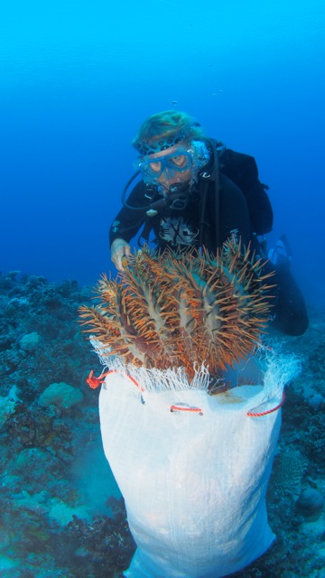
- Fabrication of collection hooks and bags, and purchase of injection guns for Crown of Thorns starfish mitigation; supplies to construct coral gardening frames.
- Transportation of conservation and food & water security materials: e.g., water collection tanks & systems; construction supplies; agroforestry/agriculture & aquaculture resources such as seedlings, fish stocks, erosion control plants.
- Operation and maintenance of snorkel equipment, dive compressor, tanks and gear and RV Llyr’s First Responder dive tender.
- Educational outreach: e.g., maintenance of portable video equipment and generator for community presentations; reef survey and coral gardening training and tool kits; Crown of Thorns mitigation; copying of DVD and paper instructional materials concerning climate change, coral reefs, agroecology, and food security strategies.
Identifying species at risk and options for establishing community-managed conservation areas. - Cultural anthropology-oriented documentary film productions for a) filming village reefs & actions for local community awareness and school presentations; and b) films for wider audiences & supporters.
- Delivery of construction skills for conservation projects: electrical, mechanical, building, plumbing, motors, alternative energy.
- Delivery of intellectual resources: expertise in agroforestry, permaculture & food security adaptations; reef ecology and reef husbandry; experience in climate change adaptation and carbon farming; artisanal harvesting and direct market practices that advantage family-scale producers; citizen science methodologies for surveying coral reefs, marine, and forest ecosystems.
Who are the Vanua-tai?
The Vanua-tai Resouce Monitor Network was created 20 years ago by the renowned community arts and activist organization, Wan Smolbag (read: “one small bag”). Initially established to address the decline of turtle populations around the main island of Efate, the group has greatly expanded its mission in response to mounting pressures in the archipelago. Today, the Vanua-tai work with their communities across Vanuatu to develop strategies for dealing with issues ranging from coastal erosion to coral reefs in crisis, from climate change impacts on food and water security to sustainable tourism, to protecting species at risk and establishing marine and land conservation areas.
The network has grown to over 400 community volunteers, individuals woven into the social fabric of their villages and islands who have stepped forward to be agents of positive change. They act as cultural mediaries, building connections between traditional ecological knowledge and practices that have evolved over generations and Western science-based information and methods.
By helping their own communities and ecosystems, the Vanua-tai are benefiting all of us by helping stem the great wave of extinctions. By some estimates, we are losing up to 140,000 plant and animal species a year. On average, one language disappears every 14 days, and with it usually goes unique ecological knowledge about the Earth. 80% of the planet’s biological diversity and 95% of its cultural diversity resides in the homelands of Indigenous peoples. Empowering the Vanua-tai is a critical part of achieving global conservation goals.
Internationally, the Vanua-tai are a model of Indigenous Peoples designing and implementing locally appropriate and culturally sensitive adaptive strategies. Their work can enrich global dialogues and strengthen global alliances responding to the collapse of biological and cultural diversity.
What makes Island Reach Different?
-
We’re efficient
— Island Reach is lean and focused on direct action.
–We work with our hands and have mechanical and construction skills. We do our own maintenance and refit on RV Llyr, allowing more funds to go directly to projects.
–Island Reach is ready to multitask, folding numerous projects into the same expedition, saving resources and encouraging collaboration.
–Offshore marine vessels are notoriously costly to operate and maintain. Conditions are rough, the ocean is relentlessly corrosive, and complex, rugged materials must be well maintained with backups for safety. This is one important reason such vital resources are mostly unavailable to conservation workers in archipelagos. Research Vessel Llyr, built in Europe, is a modest sized, heavy displacement, steel work-yacht, ketch-rigged for sail with sturdy hardware. Llyr was carefully selected and fitted for proven efficiency, durability and low cost of operations.
-
We’re a family of farmers
–Internationally, family farming is recognized for its important economic, cultural, and environmental roles (2014, International Year of Family Farming). Most Ni-Vanuatu are skilled subsistence and artisanal harvesters, feeding their families and securing small incomes from working land and sea.
–We know first hand about connections between labor and the land. We’re sensitive to the economic, generational, and environmental challenges that farm & fisher families face around the globe.
–As a vessel with kids on board, we aim to make forest and ocean conservation cool and fun for young people! Today’s youth need to be inspired by possibilities and instilled with hope and a sense of adventure.
-
We take a holistic approach
–We’re human ecologists which means we focus on relationships between people and our environments. Our approach is interdisciplinary. Advanced training in the social sciences of cultural anthropology and psychology gives us deeper understandings of forces which shape collective action, and the importance of self-representation for Indigenous Peoples.
-
We engage risk through careful planning and training
After roughly 15,000 nautical miles at sea and five years of training and volunteer work from the coast of Maine to Dominican Republic, Haiti, Panama, and across the South Pacific Ocean States of French Polynesia, Cook Islands, Tonga, and Fiji, working towards our destination of Vanuatu, we’ve build a dynamic project that:
–attests to our resourcefulness and fortitude when encountering adversity.
–demonstrates creativity, passion and dedication.
–has been well received in both the US and Vanuatu with new partners, like Mission Blue, coming on board to pitch in.
-
We keep you connected!
–We stay in touch with Island Reach Videos and social media!
–Half of the year we’re in the US engaged in Island Reach development and public/professional outreach, working the farm, and meeting BSG-Farm’s community of customers. We bring all of us a little closer to land and sea; from ridge to reef!