by gletham
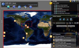
See http://geoss.esri.com/geoviewer/
Recall the other day (Wednesday) we shared details of the ESRI Flex Viewer as a great option for mapping Haiti along with related data feeds (like the USGS earthquake data to visualize the exact quake centroids).
Well, it seems the ESRI team has been hard at it this week, updating web-mapping services as well as working on web services specifically for first responders (ie. no public access, sorry) along with the map viewer (built on ArcGIS Server) found at http://geoss.esri.com/geoviewer/
This fine service enables users to quickly and efficiently visualize the area of Haiti with a number of data sources including, OpenStreetMap data, the most recent GeoEye and DigitalGlobe imagery, and USGS datasets. There are also links to the recordings from the USGS from the quake that hit on January 12.
ESRI has also developed an Earthquake Support Resource Center with useful links and pointers to data