I drove to Vermont last Friday afternoon and stayed for five days at the Killington Mountain Lodge. We were blessed with perfect weather the entire time: sunny, mild days with just the hint of a breeze. I hiked each morning on a different trail; I’m not out of shape, but none of these trails were a walk in the park, mostly because of the change in elevation. Each hike was rewarding in its own way, as I hope to show you with my photos.
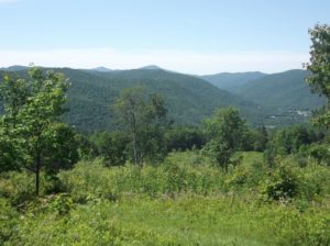
Saturday 9 June – Bald Mountain Loop Trail, starting at Notch Road. Four vistas located at rock promontories along the trail offer panoramic views of the Green Mountain range, Otter Creek, and Cold River valleys, as well as Rutland City. The East Loop is 3.3 miles long and the West Loop or Lower Loop is 0.9 miles. The hike has mostly moderate grades with a few steep descents on the West Loop and the end of the East Loop.
We could be looking at Pico Peak here. The runways at Rutland Airport are clearly visible from our vantage point.

Sunday 10 June – Contest Trail, Green Mountain National Forest. The trail starts with a pretty rugged double track climb, followed by a couple of miles of rolling single track and finishing with a double track downhill and back to Liberty Hill Road. The trail head starts 0.5 miles up FR 223/Liberty Hill Road. Much of the trail follows old woods roads. Near the southern end, the trail passes through Mayo Meadow with spectacular views.
As you can surmise, we’re resting at the Meadow, midway through the hike.

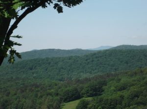
Monday 11 June – Top of the World. Top of the World is on the Bridgewater side of Route 4, across from Killington. You can get to the Top of the World Trail from the Chateauguay side.

Notice the ski trails cut into the mountain; winter skiing is very popular in this area!

Tuesday 12 June – Marsh-Billings-Rockefeller National Historical Park. We started our hike at the cemetery very near the Woodstock town center. I’m not exactly sure of our route up Mount Tom, as there were many twists and turns of the trail, but it probably went something like this: Cemetery Road to Lower Link to Precipice to the South Peak of Mount Tom, then Mount Tom Road to North Peak Trail to One Less Traveled to Summer Pasture Road past The Pogue, then Mountain Road to Upper Meadow Road, and back to our starting point, where we strolled over the covered bridge to Woodstock Common to have lunch.

This is “The Pogue” which we reached a bit past the mid-point of our hike.

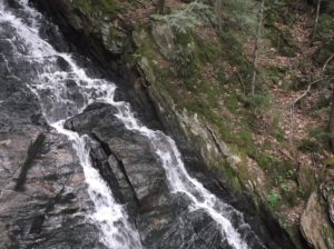
Wednesday 13 June – Appalachian Trail, Kent Pond. Thundering Falls is said to be the sixth tallest waterfall in Vermont. It is part of Kent Brook which flows out of Kent Pond just north of where the AT and the Long Trail split. At high water it is a magnificent cascade as the stream tumbles 140 feet through a steep and narrow cataract. The falls are also the site of a historic mill powered by the energy of the falling water. Starting from the River Road parking area, the AT passes through open Ottauquechee River floodplain across 900 feet of boardwalk built by the Green Mountain Club. The trail then ascends to the falls viewing platform via an accessible switchback and spur trail built by the Vermont Youth Conservation Corps. From here the AT continues its ascent through northern hardwood forest to Thundering Brook Road where a small parking lot can be found.
You can clearly see the white blaze which signifies we’re on the AT.

The blue blaze indicates a spur off the AT.

These yellow blazes indicate that this area has been surveyed and a property boundary marked.

I loved listening to the waterfall roar.
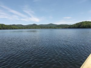
Here is tranquil Kent Pond.
Even this Canada Goose family is enjoying this beautiful summer day.

I was glad I decided on this getaway vacation, as I felt renewed and refreshed when I returned home. As you know, I lived in Vermont for four years while attending college, and I have felt an affinity for the state since then.
Note that I did not write most of the text describing each trail; I lifted these from web pages I found via Internet searches.